En fotos: las grandes inundaciones y deslaves de las últimas décadas en California
Un repaso fotográfico a las inundaciones sufridas por el 'Estado Dorado' desde 1995 y que podrían repetirse esta semana con la llegada de un río atmosférico, un fenómeno natural por el que nubes cargadas de agua del Pacífico se canalizan hasta California donde dejan fuertes precipitaciones durante días.
Las inundaciones de enero de 1995 obligaron a evacuar numerosas viviendas en Sebastopol, en el condado de Sonoma, en el norte de California.
John G. Mabanglo/AFP/Getty Images
PUBLICIDAD
2/66
Las inundaciones de enero de 1995 obligaron a evacuar numerosas viviendas en Sebastopol, en el condado de Sonoma, en el norte de California.
John G. Mabanglo/AFP/Getty Images
PUBLICIDAD
3/66
Los bomberos de Monte Río rescatan a una familia cuya vivienda quedó afectada por las inundaciones de enero de 1995 en el norte de California.
Monica Davey/AFP/Getty Images
PUBLICIDAD
4/66
Las lluvias torrenciales de enero de 1995 causaron deslaves e inundaciones en el sur de California
Mike Nelson/AFP/Getty Images
PUBLICIDAD
5/66
Las lluvias torrenciales de enero de 1995 causaron deslaves e inundaciones en el sur de California
Mike Nelson/AFP/Getty Images
PUBLICIDAD
6/66
Lluvias torrenciales causadas por últimos coletazos del huracán Nora en septiembre de 1997 anegaron las localidades costeras del sur de California. Esta imagen corresponde a la localidad de Seal Beach, en el condado de Orange.
Mike Nelson/AFP/Getty Images
PUBLICIDAD
7/66
Lluvias torrenciales causadas por últimos coletazos del huracán Nora en septiembre de 1997 anegaron las localidades costeras del sur de California. Esta imagen corresponde a la localidad de Seal Beach, en el condado de Orange.
Mike Nelson/AFP/Getty Images
PUBLICIDAD
8/66
En marzo de 1995, las fuertes lluvias causaron estragos en la localidad de Castroville, en la bahía de Monterey, en el norte de California.
Peter Dasilva/AFP/Getty Images
PUBLICIDAD
9/66
En marzo de 1995, las fuertes lluvias causaron estragos en la localidad de Castroville, en la bahía de Monterey, en el norte de California.
Peter Dasilva/AFP/Getty Images
PUBLICIDAD
10/66
El impacto dejado en California por las lluvias del fenómeno de El Niño en febrero de 1998
John G. Mabanglo/AFP/Getty Images
PUBLICIDAD
11/66
El impacto dejado en California por las lluvias del fenómeno de El Niño en febrero de 1998
John G. Mabanglo/AFP/Getty Images
PUBLICIDAD
12/66
El impacto dejado en California por las lluvias del fenómeno de El Niño en febrero de 1998
John G. Mabanglo/AFP/Getty Images
PUBLICIDAD
13/66
El impacto dejado en California por las lluvias del fenómeno de El Niño en febrero de 1998
John G. Mabanglo/AFP/Getty Images
PUBLICIDAD
14/66
El impacto dejado en California por las lluvias del fenómeno de El Niño en febrero de 1998
John G. Mabanglo/AFP/Getty Images
PUBLICIDAD
15/66
Las primeras lluvias de octubre de 2004 en las zonas afectadas por incendios durante el verano causaron deslaves y torrenteras que afectaron a áreas próximas a las montañas del sur de California, como Rancho Cucamonga.
David McNew/Getty Images
PUBLICIDAD
16/66
Las primeras lluvias de octubre de 2004 en las zonas afectadas por incendios durante el verano causaron deslaves y torrenteras que afectaron a áreas próximas a las montañas del sur de California, como Rancho Cucamonga.
David McNew/Getty Images
PUBLICIDAD
17/66
Las primeras lluvias de octubre de 2004 en las zonas afectadas por incendios durante el verano causaron deslaves y torrenteras que afectaron a áreas próximas a las montañas del sur de California, como Rancho Cucamonga.
David McNew/Getty Images
PUBLICIDAD
18/66
Las primeras lluvias de octubre de 2004 en las zonas afectadas por incendios durante el verano causaron deslaves y torrenteras que afectaron a áreas próximas a las montañas del sur de California, como Rancho Cucamonga.
David McNew/Getty Images
PUBLICIDAD
19/66
Las primeras lluvias de octubre de 2004 en las zonas afectadas por incendios durante el verano causaron deslaves y torrenteras que afectaron a áreas próximas a las montañas del sur de California, como Rancho Cucamonga.
David McNew/Getty Images
PUBLICIDAD
20/66
Las inundaciones de enero de 2005 en Santa Clarita, en California, causaron graves detrozos en viviendas. Una de ellas fue devorada por las aguas del río Santa Clara.
David McNew/Getty Images
PUBLICIDAD
21/66
Las inundaciones de enero de 2005 en Santa Clarita, en California, causaron graves detrozos en viviendas. Una de ellas fue devorada por las aguas del río Santa Clara.
David McNew/Getty Images
PUBLICIDAD
22/66
Las inundaciones de enero de 2005 en Santa Clarita, en California, causaron graves detrozos en viviendas. Una de ellas fue arrastrada por las aguas del río Santa Clara.
David McNew/Getty Images
PUBLICIDAD
23/66
Las inundaciones de enero de 2005 en Santa Clarita, en California, causaron graves detrozos en viviendas. Una de ellas fue devorada por las aguas del río Santa Clara.
David McNew/Getty Images
PUBLICIDAD
24/66
Diez personas perdieron la vida -entre ellas 3 niños- en enero de 2005 en La Conchita, California, debido a un deslave que sepultó varias casas tras unas fuertes lluvias.
David McNew/Getty Images
PUBLICIDAD
25/66
Diez personas perdieron la vida -entre ellas 3 niños- en enero de 2005 en La Conchita, California, debido a un deslave que sepultó varias casas tras unas fuertes lluvias.
David McNew/Getty Images
PUBLICIDAD
26/66
Diez personas perdieron la vida -entre ellas 3 niños- en enero de 2005 en La Conchita, California, debido a un deslave que sepultó varias casas tras unas fuertes lluvias.
David McNew/Getty Images
PUBLICIDAD
27/66
Diez personas perdieron la vida -entre ellas 3 niños- en enero de 2005 en La Conchita, California, debido a un deslave que sepultó varias casas tras unas fuertes lluvias.
David McNew/Getty Images
PUBLICIDAD
28/66
Diez personas perdieron la vida -entre ellas 3 niños- en enero de 2005 en La Conchita, California, debido a un deslave que sepultó varias casas tras unas fuertes lluvias.
David McNew/Getty Images
PUBLICIDAD
29/66
Tras las fuertes lluvias de febrero de 2005, numerosas viviendas del sur de California resultaron afectadas por los deslizamientos de terreno y el lodo.
David McNew/Getty Images
PUBLICIDAD
30/66
Tras las fuertes lluvias de febrero de 2005, numerosas viviendas del sur de California resultaron afectadas por los deslizamientos de terreno y el lodo.
David McNew/Getty Images
PUBLICIDAD
31/66
GUERNEVILLE, CA - JANUARY 2: People take water ferries via canoes and small boats back and forth to their homes off Drake road from a flood on January 2, 2006 in Guerneville, California. Northern California has been inundated by heavy rain over the past week, causing mudslides and rivers to spill over their banks. (Photo by David Paul Morris/Getty Images)
David Paul Morris/Getty Images
PUBLICIDAD
32/66
GUERNEVILLE, CA - JANUARY 2: Trailers and motor homes located at the River Bend Trailer Park sit in the water from a flood on January 2, 2006 in Guerneville, California. Northern California has been inundated by heavy rain over the past week, causing mudslides and rivers to spill over their banks. (Photo by David Paul Morris/Getty Images)
David Paul Morris/Getty Images
PUBLICIDAD
33/66
FAIRFAX, CA - JANUARY 2: Cars rest where they slid off the road during a mudslide on Tamalpias Road January 2, 2006 in Fairfax, California. Northern California has been inundated by heavy rain over the past week, causing mudslides and pushing rivers over their banks. (Photo by David Paul Morris/Getty Images)
David Paul Morris/Getty Images
PUBLICIDAD
34/66
GUERNEVILLE, CA - JANUARY 2: A car located at the River Bend Trailer Park sit in the water from a flood on January 2, 2006 in Guerneville, California. Northern California has been inundated by heavy rain over the past week, causing mudslides and rivers to spill over their banks. (Photo by David Paul Morris/Getty Images)
David Paul Morris/Getty Images
PUBLICIDAD
35/66
GUERNEVILLE, CA - JANUARY 2: A gas station on River Road sits partially under water on January 2, 2006 in Guerneville, California. Northern California has been inundated by heavy rain over the past week, causing mudslides and rivers to spill over their banks. (Photo by David Paul Morris/Getty Images)
David Paul Morris/Getty Images
PUBLICIDAD
36/66
SAN ANSELMO, CA - JANUARY 2: Johanna Sedman cleans up her store, PS Paper, after a flood waters receded January 2, 2006 in San Anselmo, California. Northern California has been inundated by heavy rain over the past week, causing mudslides and pushing rivers over their banks. (Photo by David Paul Morris/Getty Images)
David Paul Morris/Getty Images
PUBLICIDAD
37/66
NAPA, CA - DECEMBER 31: A truck drives throught the water as people clean up after a storm left much of downtown under water on December 31, 2005 in Napa, California. A powerful winter storm dumped record amounts of rain and sent rivers and creeks overflowing into many cities and towns in northern California. Forecasters are warning of another storm tomorrow that could set off more flooding and landslides. (Photo by David Paul Morris/Getty Images)
David Paul Morris/Getty Images
PUBLICIDAD
38/66
NAPA, CA - DECEMBER 31: (L-R) Michael Quinton, Dallin Blankenship and Chase Savory help residents clean up after a storm left much of downtown under water on December 31, 2005 in Napa, California. A powerful winter storm dumped record amounts of rain and sent rivers and creeks overflowing into many cities and towns in northern California. Forecasters are warning of another storm tomorrow that could set off more flooding and landslides. (Photo by David Paul Morris/Getty Images)
David Paul Morris/Getty Images
PUBLICIDAD
39/66
NAPA, CA - DECEMBER 31: Workers clean out a drain after a storm left much of downtown under water on December 31, 2005 in Napa, California. A powerful winter storm dumped record amounts of rain and sent rivers and creeks overflowing into many cities and towns in northern California. Forecasters are warning of another storm tomorrow that could set off more flooding and landslides. (Photo by David Paul Morris/Getty Images)
David Paul Morris/Getty Images
PUBLICIDAD
40/66
Una tormenta en enero de 2010 inundó las carreteras del sur de California. Estas imágenes corresponden a la autopista 710 de Long Beach.
Kevork Djansezian/Getty Images
PUBLICIDAD
41/66
Una tormenta en enero de 2010 inundó las carreteras del sur de California. Estas imágenes corresponden a la autopista 710 de Long Beach.
Kevork Djansezian/Getty Images
PUBLICIDAD
42/66
Una tormenta en enero de 2010 inundó las carreteras del sur de California. Estas imágenes corresponden a la autopista 710 de Long Beach.
Kevork Djansezian/Getty Images
PUBLICIDAD
43/66
LA CANADA-FLINTRIDGE, CA - FEBRUARY 6: A debris flow damages a home after heavy rains caused mudslides February 6, 2010 in La Canada Flintridge, California. Large wildfires in 2008 and 2009 stripped the hills and mountains of vegetation, resulting in mud and debris flow danger as winter rains pass over foothill communities where thousands of people have been evacuated at times in recent weeks. The threat is particularly high near the San Gabriel Mountains above La Canada-Flintridge area which were denuded of natural flood-controlling vegetation by the 250-plus square mile Station. At least 40 homes have been severely damaged and 500 remain evacuated. (Photo by David McNew/Getty Images)
David McNew
PUBLICIDAD
44/66
LA CANADA FLINTRIDGE, CA - JANUARY 21: Muddy water hits sand bags and a K rail in front of a house threatened with mud slides from the hill behind it during the fourth storm of the week on January 21, 2010 in La Canada Flintridge, California. Hundreds of homes have been evacuated because of the threat of major mud slides and debris flows below foothills and mountains that burned last year. Despite warnings by firefighters that they will not be able to get through debris flows to rescue stay-behind residents if a major event occurs, many refuse to leave. The threat is particularly high near the San Gabriel Mountains which were denuded of natural flood-controlling vegetation by the 250-plus square mile Station Fire. (Photo by David McNew/Getty Images)
David McNew
PUBLICIDAD
45/66
LA CANADA-FLINTRIDGE, CA - FEBRUARY 6: A crew of inmate firefighters from Azusa, California digs out cars that were swept away as debris flows damaged homes on February 6, 2010 in La Canada Flintridge, California. Large wildfires in 2008 and 2009 stripped the hills and mountains of vegetation, resulting in mud and debris flow danger as winter rains pass over foothill communities where thousands of people have been evacuated at times in recent weeks. The threat is particularly high near the San Gabriel Mountains above La Canada-Flintridge area which were denuded of natural flood-controlling vegetation by the 250-plus square mile Station. At least 40 homes have been severely damaged and 500 remain evacuated. (Photo by David McNew/Getty Images)
David McNew
PUBLICIDAD
46/66
LA CANADA-FLINTRIDGE, CA - FEBRUARY 6: Matthew Fernandez helps a neighbor shovel ankle-deep mud after debris flows damaged homes and carried cars away following heavy rains that caused mudslides on February 6, 2010 in La Canada Flintridge, California. Large wildfires in 2008 and 2009 stripped the hills and mountains of vegetation, resulting in mud and debris flow danger as winter rains pass over foothill communities where thousands of people have been evacuated at times in recent weeks. The threat is particularly high near the San Gabriel Mountains above La Canada-Flintridge area which were denuded of natural flood-controlling vegetation by the 250-plus square mile Station. At least 40 homes have been severely damaged and 500 remain evacuated. (Photo by David McNew/Getty Images)
David McNew
PUBLICIDAD
47/66
LA CANADA-FLINTRIDGE, CA - FEBRUARY 6: Firefighters drive by a mangled Pontiac car that was swept away by debris flows that damaged homes on February 6, 2010 in La Canada Flintridge, California. Large wildfires in 2008 and 2009 stripped the hills and mountains of vegetation, resulting in mud and debris flow danger as winter rains pass over foothill communities where thousands of people have been evacuated at times in recent weeks. The threat is particularly high near the San Gabriel Mountains above La Canada-Flintridge area which were denuded of natural flood-controlling vegetation by the 250-plus square mile Station. At least 40 homes have been severely damaged and 500 remain evacuated. (Photo by David McNew/Getty Images)
David McNew
PUBLICIDAD
48/66
LA CANADA FLINTRIDGE, CA - JANUARY 21: Mud flows between houses and into the street in an evacuated neighborhood during the fourth storm of the week on January 21, 2010 in La Canada Flintridge, California. Hundreds of homes have been evacuated because of the threat of major mud slides and debris flows below foothills and mountains that burned last year. Despite warnings by firefighters that they will not be able to get through debris flows to rescue stay-behind residents if a major event occurs, many refuse to leave. The threat is particularly high near the San Gabriel Mountains which were denuded of natural flood-controlling vegetation by the 250-plus square mile Station Fire. (Photo by David McNew/Getty Images)
David McNew
PUBLICIDAD
49/66
LA CANADA-FLINTRIDGE, CA - FEBRUARY 6: A debris flow damages homes and carries cars away on after heavy rains caused mudslides February 6, 2010 in La Canada Flintridge, California. Large wildfires in 2008 and 2009 stripped the hills and mountains of vegetation, resulting in mud and debris flow danger as winter rains pass over foothill communities where thousands of people have been evacuated at times in recent weeks. The threat is particularly high near the San Gabriel Mountains above La Canada-Flintridge area which were denuded of natural flood-controlling vegetation by the 250-plus square mile Station. At least 40 homes have been severely damaged and 500 remain evacuated. (Photo by David McNew/Getty Images)
David McNew
PUBLICIDAD
50/66
LA CANADA-FLINTRIDGE, CA - FEBRUARY 6: A crew of inmate firefighters from Azusa, California digs out cars that were swept away as debris flows damaged homes after heavy rains caused mudslides on February 6, 2010 in La Canada Flintridge, California. Large wildfires in 2008 and 2009 stripped the hills and mountains of vegetation, resulting in mud and debris flow danger as winter rains pass over foothill communities where thousands of people have been evacuated at times in recent weeks. The threat is particularly high near the San Gabriel Mountains above La Canada-Flintridge area which were denuded of natural flood-controlling vegetation by the 250-plus square mile Station. At least 40 homes have been severely damaged and 500 remain evacuated. (Photo by David McNew/Getty Images)
David McNew
PUBLICIDAD
51/66
LA CANADA-FLINTRIDGE, CA - FEBRUARY 6: A debris flow damages homes and carries cars away on after heavy rains caused mudslides February 6, 2010 in La Canada Flintridge, California. Large wildfires in 2008 and 2009 stripped the hills and mountains of vegetation, resulting in mud and debris flow danger as winter rains pass over foothill communities where thousands of people have been evacuated at times in recent weeks. The threat is particularly high near the San Gabriel Mountains above La Canada-Flintridge area which were denuded of natural flood-controlling vegetation by the 250-plus square mile Station. At least 40 homes have been severely damaged and 500 remain evacuated. (Photo by David McNew/Getty Images)
David McNew
PUBLICIDAD
52/66
Los vecinos de Highland (California) no olvidarán la Navidad de 2010, una fecha que pasaron retirando lodo y tratando de rescatar sus bienes entre los destrozos dejados por las inundaciones.
Eric Thayer/Getty Images
PUBLICIDAD
53/66
Los vecinos de Highland (California) no olvidarán la Navidad de 2010, una fecha que pasaron retirando lodo y tratando de rescatar sus bienes entre los destrozos dejados por las inundaciones.
Eric Thayer/Getty Images
PUBLICIDAD
54/66
Los vecinos de Highland (California) no olvidarán la Navidad de 2010, una fecha que pasaron retirando lodo y tratando de rescatar sus bienes entre los destrozos dejados por las inundaciones.
Eric Thayer/Getty Images
PUBLICIDAD
55/66
Un gran deslave afectó a la localidad de Azusa, en el condado de Los Ángeles, en marzo de 2014.
David McNew/Getty Images
PUBLICIDAD
56/66
Un gran deslave afectó a la localidad de Azusa, en el condado de Los Ángeles, en marzo de 2014.
David McNew/Getty Images
PUBLICIDAD
57/66
Las lluvias del mes de diciembre de 2014 causó graves trastornos al tráfico y daños en vehículos en el área de la bahía de San Francisco, en California.
Justin Suvillan/Getty Images
PUBLICIDAD
58/66
Las inundaciones en tierra son uno de los más fuertes peligros para los residentes de la Bahía de San Francisco, como consecuencia de las mareas altas en el Océano Pacífico, además de las lluvias torrenciales.
Justin Suvillan/Getty Images
PUBLICIDAD
59/66
Un frente tormentoso que primero anegó el norte de California en diciembre de 2014 llegó al sur del estado donde en lugares como Camarillo causó deslizamientos de rocas que destrozaron varios hogares.
David McNew/Getty Images
PUBLICIDAD
60/66
Un frente tormentoso que primero anegó el norte de California en diciembre de 2014 llegó al sur del estado donde en lugares como Camarillo causó deslizamientos de rocas que destrozaron varios hogares.
David McNew/Getty Images
PUBLICIDAD
61/66
Un frente tormentoso que primero anegó el norte de California en diciembre de 2014 llegó al sur del estado donde en lugares como Camarillo causó deslizamientos de rocas que destrozaron varios hogares.
David McNew/Getty Images
PUBLICIDAD
62/66
Un frente tormentoso que primero anegó el norte de California en diciembre de 2014 llegó al sur del estado donde en lugares como Camarillo causó deslizamientos de rocas que destrozaron varios hogares.
David McNew/Getty Images
PUBLICIDAD
63/66
Numerosos vehículos quedaron atrapados por un deslave enterró la autopista 58 en Mojave (California) el 16 de octubre de 2015.
Mark Ralston/AFP/Getty Images
PUBLICIDAD
64/66
Numerosos vehículos quedaron atrapados por un deslave enterró la autopista 58 en Mojave (California) el 16 de octubre de 2015.
Mark Ralston/AFP/Getty Images
PUBLICIDAD
65/66
Numerosos vehículos quedaron atrapados por un deslave enterró la autopista 58 en Mojave (California) el 16 de octubre de 2015.
Mark Ralston/AFP/Getty Images
PUBLICIDAD
66/66
Numerosos vehículos quedaron atrapados por un deslave enterró la autopista 58 en Mojave (California) el 16 de octubre de 2015.


 1/66
1/66 2/66
2/66 3/66
3/66 4/66
4/66 5/66
5/66 6/66
6/66 7/66
7/66 8/66
8/66 9/66
9/66 10/66
10/66 11/66
11/66 12/66
12/66 13/66
13/66 14/66
14/66 15/66
15/66 16/66
16/66 17/66
17/66 18/66
18/66 19/66
19/66 20/66
20/66 21/66
21/66 22/66
22/66 23/66
23/66 24/66
24/66 25/66
25/66 26/66
26/66 27/66
27/66 28/66
28/66 29/66
29/66 30/66
30/66 31/66
31/66 32/66
32/66 33/66
33/66 34/66
34/66 35/66
35/66 36/66
36/66 37/66
37/66 38/66
38/66 39/66
39/66 40/66
40/66 41/66
41/66 42/66
42/66 43/66
43/66 44/66
44/66 45/66
45/66 46/66
46/66 47/66
47/66 48/66
48/66 49/66
49/66 50/66
50/66 51/66
51/66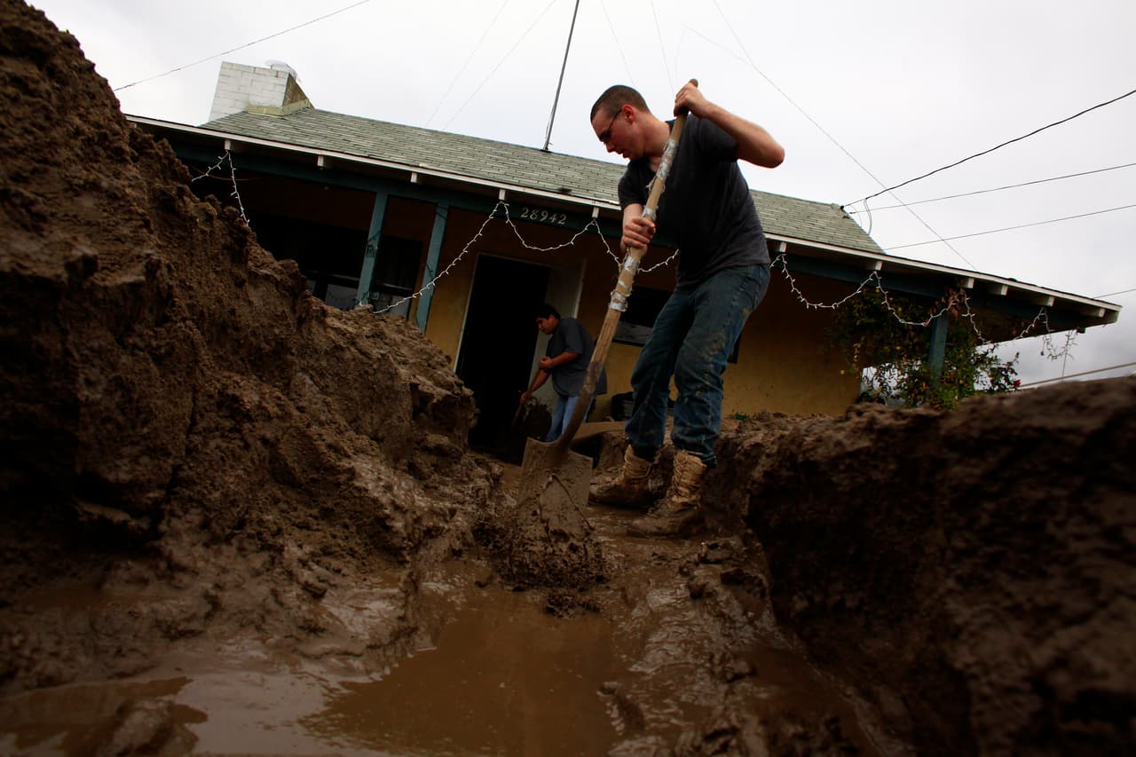 52/66
52/66 53/66
53/66 54/66
54/66 55/66
55/66 56/66
56/66 57/66
57/66 58/66
58/66 59/66
59/66 60/66
60/66 61/66
61/66 62/66
62/66 63/66
63/66 64/66
64/66 65/66
65/66 66/66
66/66